Geographic Information Systems (GIS) are a combination of spatial data and computer programs. Any variety of maps can be created with a GIS by combining data with aerial photos. The GIS can determine relationships within data sets and also how it relates to other data sets. The relationships can show categories or spatial patterns, which can be interpreted to create useful knowledge.
Flagstaff County uses GIS systems for land use planning, public works project management, farmland assessment, rural addressing, inventorying of county property and infrastructure, and fleet tracking.
Why not spend a few minutes checking out Webmap?
Flagstaff County WebMap
WebMap offers access to a wide range of useful municipal land information, including detailed aerial photography.
Among this handy online tool’s many practical applications, WebMap allows landowners to accurately calculate arable acres on their property, for instance. Other searchable information includes soil classification, land elevation, pipelines, wells, roads, right-of-ways, property lines, legal land locations, township grids and municipal boundaries.
While all tools and features have been designed to be intuitive, there is a help button at the bottom of the toolbar for instructions.
Disclaimer: Flagstaff County shall not be held responsible for any errors or omissions. There shall be no use of data for commercial profit by any way, shape or form, without prior written consent from Flagstaff County. Data is provided to the general public as general information.
Click HERE to enter the WebMap site (log in as a guest).
For tips on using WebMap, click HERE.
Munisight Video Collection
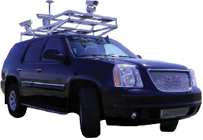
Flagstaff County retained Accurate Assessment Group Ltd. to drive the roads in the municipality in both directions.
VDC provides safe capture and a cost-efficient view of the municipality’s road and roadside assets to enhance the Geographical Information System (GIS).
Contacts